 | ▪ Bronx River Revival
▪ How Government Works in the 21st Century
▪ Bronx River One-Mile Pathway
▪ A Glimpse of Nature On Display
▪ Bronx River Trail, Pathway & Nature Reserve
▪ Yonkers-Mount Vernon One-Mile Trail
▪ The Bronx River
▪ Getting There
▪ One-mile Nature Reserve and Pathway
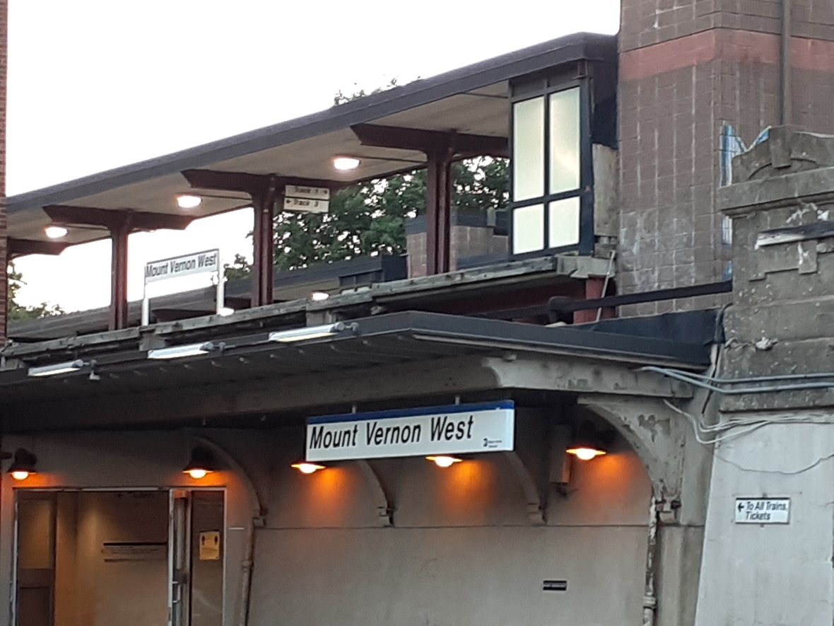
▪ Mount Vernon West
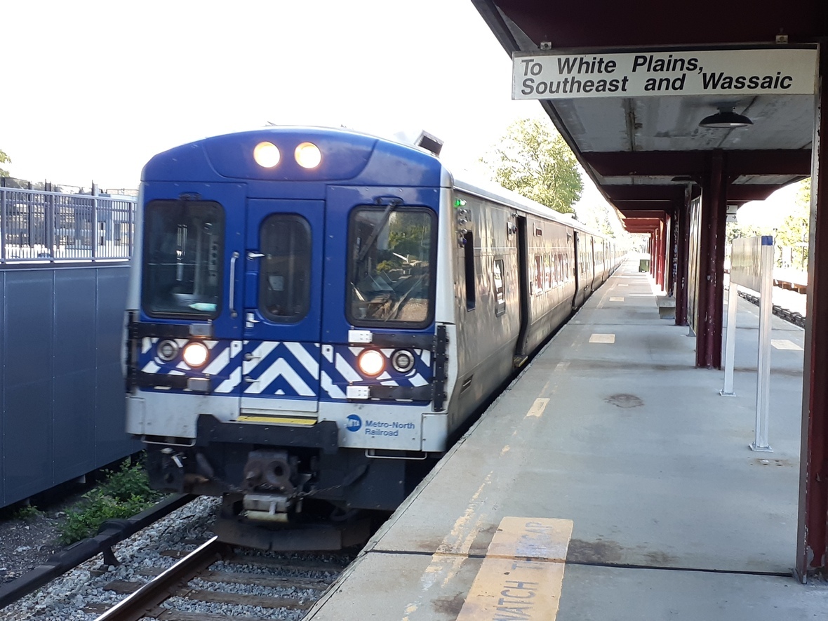
▪ Grand Central Terminal
▪ White Plains
▪ Southeast
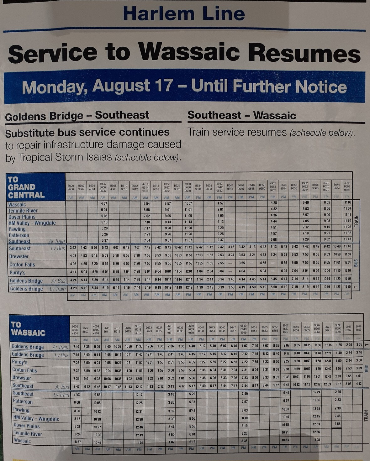
▪ WASSIC PANDEMIC SCHEDULE
▪ Harlem Valley Rail Trail
▪ Harlem Line
▪ Going By Car
▪ Coming Up From the City
▪ Cycling Along The Bronx River
▪ Cycling In The Bronx
▪ One Trail, Two Jurisdictions
▪ The Hudson River
▪ Yonkers Raceway
▪ Southeast Yonkers
▪ Unique Micro-Reserve
▪ Pathway Visitors
▪ Five New Luxury Apartment Complexes Converge on Bronx River Pathway's Community And Fragile Ecology
▪ Stagg Group
▪ MacQuesten Development, LLC
▪ Greater Community Involvement Needed
▪ 22 South West Street
▪ 130 Mount Vernon Avenue
▪ 412 Bronx River Road
▪ 697 Bronx River Road
▪ 1219 Yonkers Avenue
▪ Nature On Display
▪ Westchestergov Ignores Bronx River One-Mile Nature Trail
▪ Nature Works in Miraculous Ways
▪ Role Of Westchester Park Services
▪ Rotting Trees
▪ Motorized Vehicles
▪ Bottles, Cans and Debris Everywhere!
▪ MTA Trucks & Rail Equipment Often Dominate The Pathway and Walking Trail
▪ Bronx River Speedway
▪ Increased Police Activity On Bronx River Parkway Access Ramp
▪ Crossing the Bronx River Parkway Access Ramp to Enter The Pathway and Micro-Nature Reserve is a Dangerous Endeavor to Undertake
▪ Improved Coordination Needed Between Park Services, MTA & State and County Road Works
▪ Stop Trespassing on County Park Property Held in Trust For the People
▪ Bronx River Pathway
▪ A Gift From Nature
▪ Tropical Storm Isaias
▪ County Inter-Park Clean-up Comparison
▪ Museum of Natural History & Queens College Effort in Bronx River Pathway Nature Reserve
▪ Urban Ecology
▪ Biking Along The Hudson
▪ Biking On The Bronx River in Westchester County
▪ Take The Bike To The Train
▪ Mount Vernon West vs. Mount Vernon East
▪ Getty Square
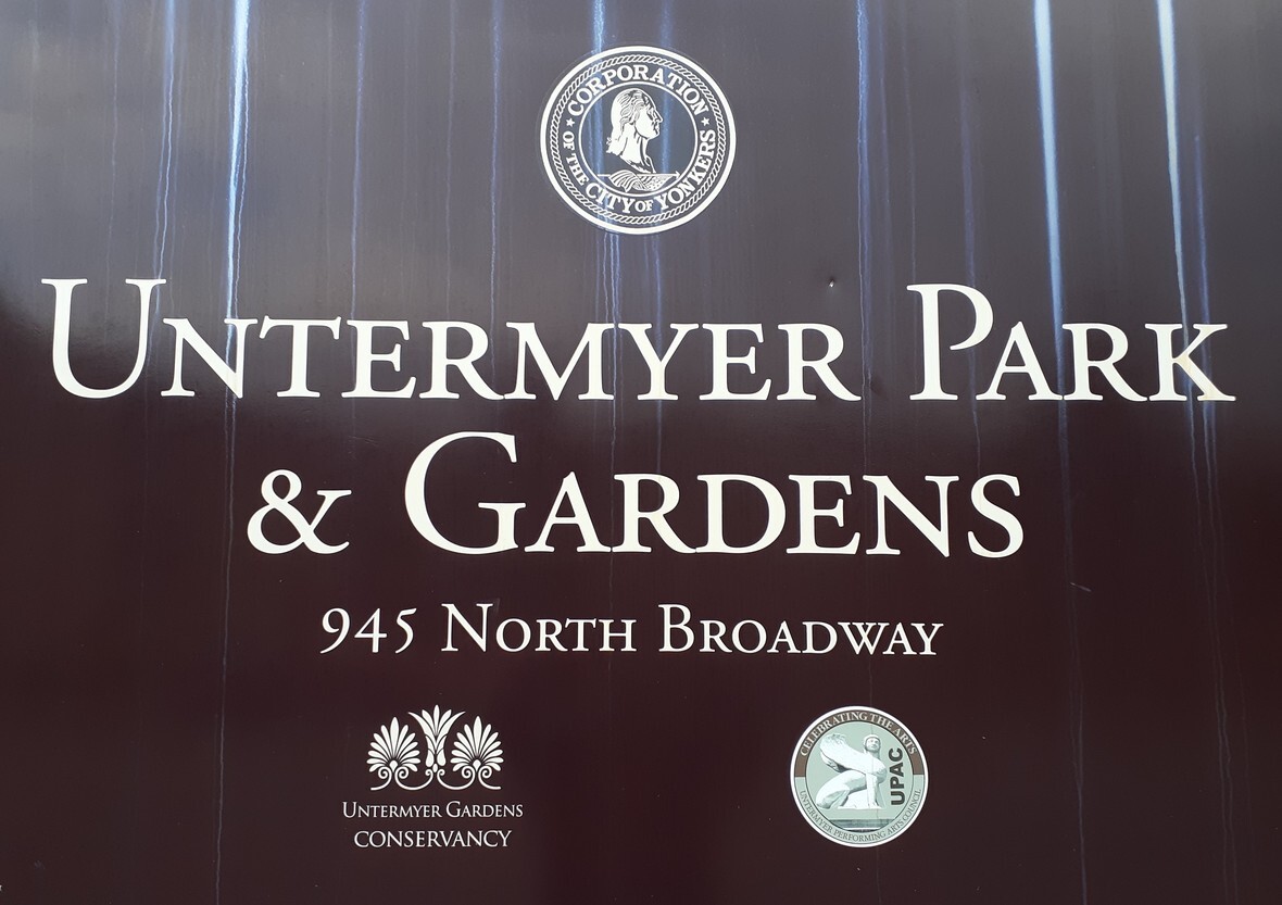
▪ Untermyer Gardens Conservancy
▪ Van Cortlandt Park
▪ Preparing for the Next Pandemic
▪ Demand Notice
▪ Distribution
▪ Guide to COVID-19 Antidote, Celestial Affairs newsletters, podcasts, interviews, articles, blogs and more!
▪ WaterMagi
▪ Change Your Water, Change Your Life
▪ Solid Carbon Block Technology
▪ Articles on Water
▪ Drinking Water Information & Resources
▪ Join Our Distribution List
|  Video: COYOTES IN NEW YORK: URBAN ECOLOGY: Bobby, Queens College, July 1, 2020: Click Image | | Bronx River One-Mile Pathway: A Glimpse of Nature on Display is an intimate look at a forgotten strip of nature reserve in Southeast Yonkers/Mount Vernon border in lower Westchester County, New York that represents a microcosm of government agencies on display. This forgotten piece of real estate bears the brunt of all that is wrong in government and local authorities as they continue their grand romantic liaison with large inorganic, fictional institutions and corporations that have taken control of human life and affairs in every sphere and quarters of living, working steadfastly, progressively and dutifully against the natural order of things commonly known as nature. This largely pictorial essay highlights a similar trend seen in parks throughout the country, which in some sense represents the state of community life in the 21st century. Progress denied! |  Bronx River Parkway, Yonkers, New York | | | A Forgotten & Abused Piece of Real Estate | Hello Park Patrons and Fellow Citizen,
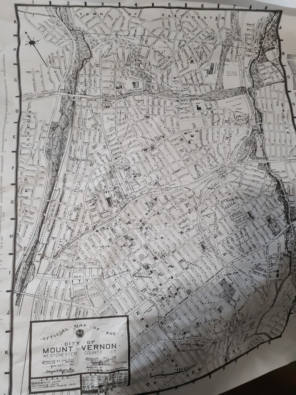
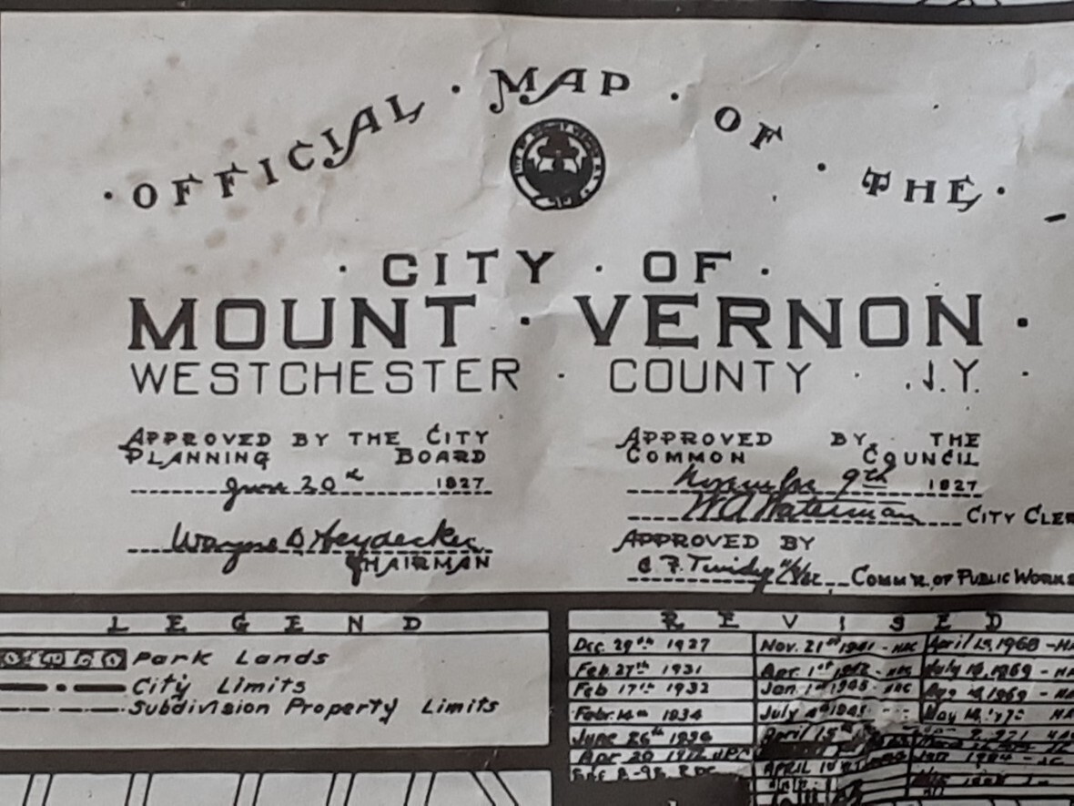
Subscribe to our newsletter here. Over the summer of 2020, I visited Bronx River Pathway in Southeast Yonkers with Veteran Horticulturalist, business owner, event floral designer, cyclist and aspiring Tour de France contender, Rene Hofstede . This unique nature trail is located at Yonkers-Mount Vernon border at Sherwood Avenue and Bronx River Road. It hosts a beautiful one-mile scenic trail that sits along side the Bronx River. This article provides a full and thorough understanding of the exquisite nature of this delicate microcosm and the ongoing situation there. We see change coming in the future, and hope it is change that will go in the right direction to make this nature trail more accessible to people living in the area. This communique is written to help preserve the fluctuating ethereal balance between nature and man's needs, behavior, action, desire, sense of community and social responsibility. | SHARE WITH INTERESTED PARTIES & ON SOCIAL MEDIA VIA THIS LINK: https://gem.godaddy.com/p/c75b1b1 |  Harlem Line, first street railway in the world, 1832 | | | This one mile stretch of river view nature trail, walking, jogging, biking pathway, with a green meadow spot at the top, is located in Southeast Yonkers east of Bronx River Road and Sherwood Avenue. It is 5.3 miles north of The Bronx Botanical Garden, renamed New York Botanical Garden, NYBG. (The Bronx Botanical Garden was renamed to attract a broader demographics and audience.) This narrow strip of river view property offers a different view and experience than one would normally find in well maintained and manicured county and city parks in Westchester County and in America. It is a hidden gem that is close to nature that only a few know about. |  The Bronx River on the Yonkers-Mount Vernon border. | | The Bronx River, the only fresh water river in New York City, opens up on East Fordham Road in the Bronx starting at the New York Botanical Garden and empties into the East River at Hunts Point in the Bronx, but in Yonkers and Mount Vernon it maintains its narrow, winding character from its origins in Valhalla. |  The Bronx River at New York Botanical Garden | | 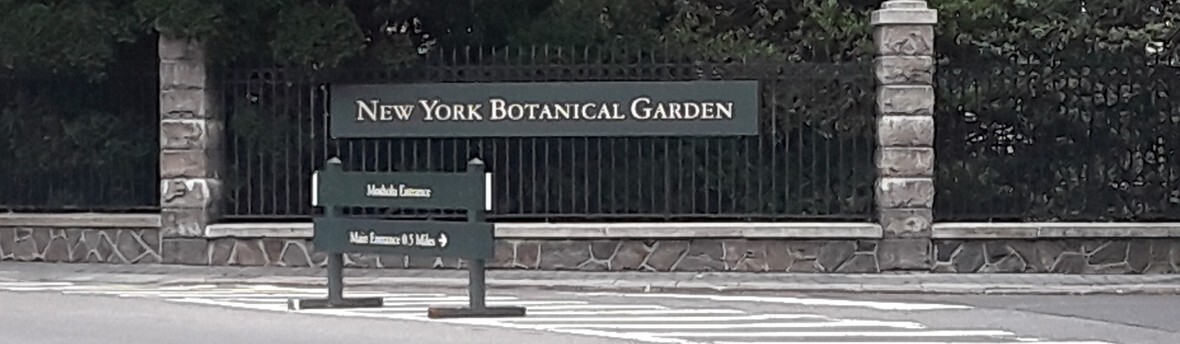 New York Botanical Garden, Bronx , New York | | | 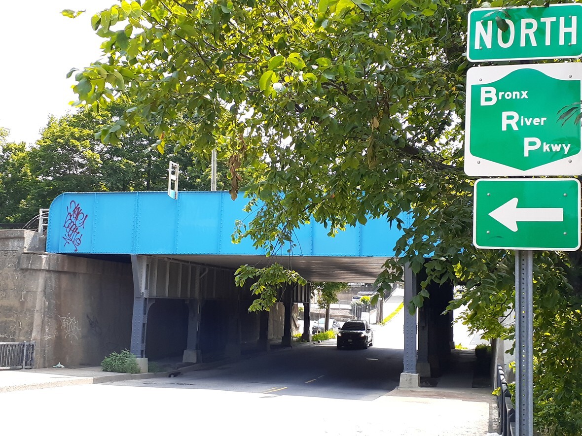 Follow the arrow to get on the river view pathway. | | |  Pathway approach from Oak Street, Mount Vernon |  Western approach from Mount Vernon | | |  Intersection of Bronx River Road, Yonkers Avenue & Mount Vernon Avenue |  Intersection of Bronx River Road, Yonkers Avenue & Mount Vernon Avenue | | |  Yonkers Avenue, Exit 10A Bronx River Parkway - North. Mount Vernon West station in background. |  Exit 10A Bronx River Parkway - north | | | To get there from Manhattan by car, take Yonkers Avenue, Exit 10A on the Bronx River Parkway going north. Exit 10A empties out at Mount Vernon Avenue, Yonkers Avenue and Bronx River Road, which are to your immediate left upon exiting the parkway. Yonkers Avenue to the left of 10A is the same as Mount Vernon Avenue east of Bronx River Road where Mount Vernon West Metro-North train station sits at 1 Mount Vernon Avenue. This hidden and secluded nature trail is located one block northwest of this exit point at the triple joint intersection of Sherwood Avenue, Bronx River Road and Oak Street. Oak Street is the eastern corridor and continuation of Sherwood Avenue which connects the two cities at this critical juncture. Local street addresses that you may plug into your GPS device to find nearby street parking is 475 Bronx River Road, Yonkers, New York 10704 or 21 Sherwood Avenue, Yonkers, New York 10704. These two local addresses are the closest identifiable points to the Pathway's entrance that is directly across the nearby bridge that crosses over The Bronx River Parkway going into Mount Vernon. These "dummy" addresses are no more than 80 yards (or steps) from the Bronx River Pathway's curbside highway ramp entrance that takes you onto the trail. If you look closely from 475 Bronx River Road it is possible to see the Bronx River Pathway's curbside walkway entrance that sits adjacent to, i.e., alongside, the highway ramp that leads onto the Bronx River Parkway. Once you find parking, look for MTA's sky blue overhead bridge on Oak Street (shown in photos above) as your marker to the park's 300 yards asphalted curbside walkway entrance that magically leads to the trail's hidden and obscured cross over bridge (see below). | This one mile nature reserve and pathway runs beside the Bronx River, the Bronx River Parkway and MetroNorth's historic Harlem Line. It is perhaps the best and most spectacular section of the entire Bronx River that very people know about. In this regard, it is one of Westchester and New York State's best kept secret. |  Curbside walkway that leads to Bronx River One Mile Pathway via a Cross Over Bridge | | |  Walkway approach to Cross Over bridge |  Cross Over Bridge, maintained by community efforts | | |  Cross Over bridge that takes you into the Bronx River Pathway | | | A small Park Services sign (shown above) identifying the Bronx River Pathway lets you know you're at the right spot. |  From Street Cars to High Speed Commuter Rail, the Harlem Line has come a long way. | | Bronx River Parkway | | | The Bronx River Pathway at the Yonkers-Mount Vernon border is within a one block (7 minutes, 0.3 mile) walking distance from MetroNorth's Mount Vernon West station on the HARLEM LINE. | Grand Central Terminal opened in 1871. It's opening provided the economic impetus and stimulus to build skyscrapers and office buildings, such as the Chrysler Building in mid town Manhattan, prior to which no one wanted to venture south of 42nd Street. Cornelius "Commodore" Vanderbilt dominated New York State and Westchester's railway industry. In 1913, the new electrified Grand Central Terminal (GCT) opened that led to many infrastructure improvements that supported GCT's operations. Today, it is the 3rd busiest rail terminal in North America. Many of the infrastructure improvements were made in Westchester County, such as added tracks and electrification systems at Harmon Shop. The Harlem Line originates in Manhattan at Grand Central Terminal on 42nd Street and travels up to White Plains and Southeast (Brewster) on an ongoing basis day and night. The Line truncates in Eastern New York at Wassaic, with old trackage further north from The New York & Harlem Railroad turned into a scenic 26 miles bike trail that will expand to 46 miles in the near future. GCT has come under pressure on more than one occasion to replace its timeless architecture with modernistic, efficient, high revenue stream building design that would cram commuter flow through narrow hallways, robbing it of its many entrances, glorious open space, historical value and appeal to culture and heritage as was successfully accomplished at the once classic and culturally important Pennsylvania Station at Herald Square, which is now faced with serious overcrowding problems. Fortunately, those plans never materialized or came to fruition to change the sense of wonder, open space, Zodiac blueprint, solar and cosmic intelligence that Grand Central Terminal provides and offers. |  Near The Bronx River | | |  Southeast (Brewster) is 7 miles west of Danbury, Connecticut | | | The town of Wassaic is located six miles west of New York's eastern border with Connecticut. The Harlem Line terminates at Wassaic during weekdays, Monday through Friday. Unfortunately, there is no service to Wassiac on weekends, during these challenging times, to allow access to their 26 miles paved railway bike trail and Wassaic creative arts project, which are signature projects that the town vehemently supports. |  Bike Storage Bins at Wassaic Station |  Harlem Valley Rail Trail Starts At Wassaic Train Station |  Wassaic Station | | |  Engine 128 on the Southeast to Wassaic Track |  Bike Shop at Wassaic Commons | | |  Harlem Valley Rail Trail Starts Here - Part of 488 acre Multiple Use Area! |  Harlem Valley Rail Trail Starts Here! | | |  Wassaic Project for Creative Artists & Writers |  Wassaic Project for Creative Artists - Harlem Valley Rail Trail Starts Here at Nelson Hill Road and Furnace Bank Road. | | |  Main Street, Wassaic |  Yoga at the Wassaic Project | | |  Harlem Valley Rail Trail & Harlem Line Track |  Ooops! Over the fence she goes... | | |  Where's the train on the Harlem Line, we wanna go home!!! |  To be or not to be... | | |  All aboard! |  Open space for luggage and bikes! | | |  Harlem Valley Rail Trail - click here! |  Harlem Valley Rail Trail Map - click here! | | | The Harlem Valley Rail Trail is a paved rail trail on an abandoned portion of The New York & Harlem Railroad, located further north of Metro-North's Harlem Line terminus at Wassaic. The abandoned rail line was converted into a public park in 1989. Plans have been approved to expand the trail further north (beyond the current terminus in Taconic State Park) to Chatham, which would make the total length of the rail trail approximately 46 miles (74 km). | The Harlem Line got its name from The New York & Harlem Railroad in 1832 which was the nation's first street railway, originally pulled by horses, (see archive photo above) that was initially supposed to go from City Hall at Brooklyn Bridge to a dock on the Harlem River near 135th Street, but submit to pressure to go further north outside of Manhattan to White Plains by 1846. Unlike New York's Harlem and Hudson lines, which provide meager space for bikes in some cars, Connecticut's MetroNorth New Heaven Line goes all the way to support cyclists and bikers by upgrading all of their trains to include bike racks, which makes it perfect for cyclists who want to bike along the eastern corridors of Westchester County, and on trails that are east, central and west of Connecticut. While the Harlem and Hudson Lines are not bike friendly, they do provide some space for bikes. |  MetroNorth New Haven Line |  Bike Racks Available on MetroNorth's New Haven Line Covering Eastern Westchester and the State of Connecticut | | |  HARLEM LINE: Bronx River One Mile Pathway |  HARLEM LINE: Bronxville, New York | | | Yonkers Avenue, Exit 10A North (Exit 10B South), Bronx River Parkway | | | If you're not biking, perhaps going for a picnic or some other planned session on the green or near the adjacent river on the Bronx River One-Mile Pathway, accessing this splendid river view nature reserve in Southeast Yonkers by car is convenient; 25 minutes drive from the Upper West Side of Manhattan; 8-20 minutes train ride from Metro-North's Harlem-125th Street station depending on commuter rush hour traffic and time of day. | You'll find a lot of individuals and groups cycling on Bronx River Road (Webster Avenue in the Bronx starting at Nereid and McLean Avenues), especially on Sunday mornings. Bronx River Road provides easy access to the Bronx River Pathway trails in Southeast Yonkers/Mount Vernon West location and in Bronxville from Palmer Road. You can access Bronx River Pathway 5.0-mile trail in Hartsdale from Harlem Line Metro-North Hartsdale station or by navigating from the end of the 4.6-mile trail that starts in Bronxville on Palmer Road. | There are cycling pathways along The Bronx River in The Bronx that you may want to visit as a starting point before connecting with trails in Westchester County. Visit New York City Bronx River Bike Map for more information. | There are two entrances to this one mile nature-reserve. One entrance is located to the north under the jurisdiction of The City Mount Vernon and the other to the south in Southeast Yonkers. The biking and pedestrian entrance to this micro-reserve is officially located in Southeast Yonkers with a northern curbside dirt road access point in the north that provides roadway access to construction trucks and heavy duty rail equipment as well as state, county and city vehicular traffic that wants or needs to gain access to the park and/or Metro-North's Mount Vernon West Gate railway train yard that is situated there. The City of Mount Vernon shares Bronx River Pathway One-Mile Trail with The City of Yonkers in a particular and serpentine way. The border between these two Westchester cities, shown on the official City of Mount Vernon map above, zigzags through the park and walking trail perhaps reflecting the original course of The Bronx River before the Bronx River Parkway and Metro-North Harlem Line (first street car company in the world) were built in the early 19th century. As noted above, the Harlem Line was franchised, on April 25, 1831, to run between the original city core in lower Manhattan to a dock on 135th Street on the Harlem River, but that soon changed as demand for rail commuter traffic increased throughout the region. | The Hudson River is 4 miles West of the Bronx River Pathway's location on Sherwood Avenue. Yonkers Avenue connects these two essential sister rivers going west pass Yonkers Raceway and Empire City Casino towards Yonkers municipal downtown city center at Getty Square. |  Yonkers Raceway & Casino on Yonkers Avenue | | | | Walk Gently, Don't Disturb The Wildlife! Southeast Yonkers-Mount Vernon West | The unique beauty and character of this isolated micro-heaven in Southeast Yonkers comes from it being cut-off and sandwiched in its own parcel of protected micro-space by major County and State infrastructure dividers. MetroNorth Harlem Line to the east of The Bronx River and The Bronx River Parkway to the west are the major transportation thorough ways that separate this reclusive one-mile nature corridor from the two 4.6-mile and 5-mile Bronx River Pathways that are accessible from Bronxville and Hartsdale further north, respectively, making this one-mile pathway strip a tricky place to find and access, but once you're there, you'll experience a reverence for nature that you won't easily find elsewhere. You know this because the noise level drops precipitously once you enter the park, even though you can still hear the sound of traffic on The Bronx River Parkway to the west and the bustling sound of passing trains to the east from MetroNorth's Harlem Line. These busy north-south throughput arteries run parallel on either side of The Bronx River from beginning to end. The Pathway itself is cut-off at the top and bottom by the exit ramp of Exit 11E (east) coming off The Bronx River Parkway and the busy Sherwood Avenue and Oak Street inter-connection to the south of the park, locking in this unusual microbe of nature into a narrow rectangular, but isolated serpentine space shown on the City maps above. | Few people in the surrounding nearby communities visit the park and nature trail. On a good day during the week you'll get 5, up to 10 people visiting the park. On weekends, perhaps more. Most in the surrounding communities don't know the park, jogging and biking trail exist or is there, but this may change in the future with the already completed, under construction and planned completion of five new luxury apartment buildings promising to add a minimum of 679 new apartment units to the area's already saturated housing community, putting these new residents within walking distance of the Pathway's curbside ramp walkway on Sherwood Avenue. | In the summer of 2020, five (5) new apartment buildings have been constructed in Southeast Yonkers/Mount Vernon West border community increasing the flow of traffic and availability of limited resources in a densely populated housing, transit-oriented development scheme independently promoted by the cities of Yonkers and Mount Vernon, which centers around maximizing the benefits of living close to Mount Vernon West train station. As mentioned earlier, this busy commuter train station is only one block away from Bronx River Pathway One-Mile jogging and nature trail located near the corner of Sherwood Avenue and Bronx River Road. Three of these new apartment buildings are on the Yonkers side of Bronx River Road and two are located on the Mount Vernon side of that busy intersection. Four of these buildings are within 300 yards to 1,000 yards away from Bronx River Pathway's entrance walkway. The fifth building, located at 705 Bronx River Road, is about 0.6 mile away Bronx River Pathway's walkway entrance on Sherwood Avenue. Four of these new luxury apartment buildings opened within the past 12 months, bringing 459 new apartment units to the area . The fifth, sited at the corner of Yonkers Avenue and Bronx River Road across from Mount Vernon West train station at 1219 Yonkers Avenue, has not started construction as of November 11, 2024. These sites are within walking distance of the Bronx River Pathway at Sherwood Avenue and adjacent to Mount Vernon West train station are as follows: 1. 412 Bronx River Road, Yonkers, New York (44 units, 9 stories)
2. 1219 Yonkers Avenue at Bronx River Road, Yonkers, New York (Tribune article) (estimated 220-295 units, 17 stories)
3. 705 Bronx River Road, Yonkers, New York, (160 units, 9 story)
4. 22 South West Street, Mount Vernon, New York (22SouthWest) (174 units, 20 stories)
5. 130 Mount Vernon Avenue, Mount Vernon, New York (81 units, 11 stories)
| 1. | 412 Bronx River Road, Yonkers, New York (44 units, 9 stories) | | 2. | 1219 Yonkers Avenue at Bronx River Road, Yonkers, New York (Tribune article) (estimated 220-295 units, 17 stories) | | 3. | 705 Bronx River Road, Yonkers, New York, (160 units, 9 story) | | 4. | 22 South West Street, Mount Vernon, New York (22SouthWest) (174 units, 20 stories) | | 5. | 130 Mount Vernon Avenue, Mount Vernon, New York (81 units, 11 stories) | The total number of new apartment units being introduced to the Southeast Yonkers, Mount Vernon West twin-town community between 2019 to 2022 is 679, representing a minimum residential increase of 1,500 people. This will have a direct environmental impact on Bronx River Pathway One-Mile Trail in Southeast Yonkers as the secluded trail become better known to residents moving into the area. Stagg Group is the developer for two of the five new apartment buildings located at: 1. 412 Bronx River Road (completed late 2019); and
2. 797 Bronx River Road (recently completed).
| 1. | 412 Bronx River Road (completed late 2019); and | | 2. | 797 Bronx River Road (recently completed). | 22 Southwest in Mount Vernon is developed by MacQuesten Development, LLC. This 20 story high rise is next door to Mount Vernon West train station. This property completed construction earlier this year and is managed by Cornell Pace, Inc. The Modern at 130 Mount Vernon Avenue is also developed by MacQuesten Development, LLC. It completed construction in 2019 and is located next to Mount Vernon West train station. Four of these newly completed construction clusters around Mount Vernon West train station and are within 5 to 7 minutes walk from Bronx River Pathway. The fifth luxury apartment building at 697 Bronx River Road developed by Stagg Group is a 10 minutes walk away from the Bronx River Pathway and 15 minutes (0.7 mile) walk from Mount Vernon West station. Word on the street is that Valvoline did not want sell the property site located at 1219 Yonkers Avenue. Previous offers from potential real estate developers apparently failed. | As some have pointed out, it would be good if the mayors of both cities could bring developers, county and state officials together to work towards ensuring that Bronx River Pathway One-Mile Nature Strip on the Southeast Yonkers-Mount Vernon West border gets the funding, support and environmental protection it needs to survive ecologically in a busy and expanding housing and commuter environment. New residents moving into the community will benefit from the river views and recreational resources provided by the Bronx River Pathway. | | One Block From Bronx River Pathway Adjoins Mount Vernon West Station | | One Block From Bronx River Pathway Across From Mount Vernon West Station | | One Block From Bronx River Pathway Across From Mount Vernon West Station | | 0.5 Miles From Bronx River Pathway 0.6 Mile From Mount Vernon West Station | Proposed Site One Block From Bronx River Pathway Across From Mount Vernon West Station The property is owned by Valvoline. The site remains empty and vacant. No development started as of November 11, 2024. | Westchester Park Services has completely ignored this narrow patch of abandoned nature reserve and endowment over many years. It is almost certain that unlike like other parks in the County, they do not have a budget for it. It's just there with minimum and sparse maintenance and protection. Recently it seems that MTA MetroNorth Mount Vernon West Yard has taken possession of the park by parking trucks and heavy duty rail equipment for prolong periods of time lasting weeks, even months. What's worst is that you can see these equipment from afar as soon as you enter the park, which makes this an environmental nightmare. Local newspapers won't investigate or write about these stories in an era of global corporate media control where only the interests of the state and supra-natural organizations are represented, hence the local community needs to get involved to counter this onslaught of artificial intelligence and power. For much of its existence, this nature trail has been abandoned property for County, State, Environmental and Park authorities, a forgotten part of the Bronx River Parkway Reservation in Westchester County since it opened in 1925. |  Bike Path Ends Here, but not for MTA equipment. State endorsed power has its privileges. | | |  Construction Equipment & Ducks |  Gravel & Ducks | | |  Truck, Equipment, Ducks, Gravel, Open Gate, Bike Path Ends Here on County park property! Which items don't belong? |  Truck, Jogger, Gravel on County park property! Which items don't belong? |  Joggers on County park property amidst the debris! | | | Unbelievable to some, but true in nature, this gross neglect and negligence adds to the park's natural beauty, aroma, atmosphere and attraction by reducing human traffic allowing birds, turtle, rabbits, ducks, geese and other wildlife to take over and dominate the park, but this may not last for long. There are times when it looks like a fairy land where you are surrounded by birds, squirrels, rabbits and other animals from every direction. Increased traffic from new residents will put pressure on wildlife freedom of movement and habitat in the near future. | Westchester Park Services has a role to play if it chooses to step up to its duties and responsibilities to create harmony, environmental protection and sustenance to form a promising conservatory relationship between man and nature. This can be achieved by stop catering to the organizational demands and needs of the MTA at the expense of joggers and bikers visiting the park. At a minimum, the County should: 1. Clean up The Bronx River in this one-mile stretch to standards already met in the 4.6-mile and 5.0-mile sections of the Bronx River Parkway Reservation which originates in Bronxville and Hartsdale in Westchester County;
2. Prevent engine oil, grease, chemicals and other agents from running off from MTA's Mount Vernon West Gate Yard into the adjacent Bronx River (see below).
3. Remove all garbage, cans, bottles and dated debris on open display, some sunken and embedded in the bushes of the Pathway's side shrubs and foliage that sit on either sides of the trail's walkway, some of which goes back more than 20 years suitable for profound archaeological discoveries and research;
4. Keep fallen trees in their natural state and habitat provided they do not pollute or obstruct the flow of the river, impede usage and/or visibility of the lawn areas or block access to the walking and biking trails in order to maintain the reserve's natural look and affinity to nature; and finally but not least
5. Improve coordination between Park Services, Highway Works Department and MTA as discussed above and below.
| 1. | Clean up The Bronx River in this one-mile stretch to standards already met in the 4.6-mile and 5.0-mile sections of the Bronx River Parkway Reservation which originates in Bronxville and Hartsdale in Westchester County; | | 2. | Prevent engine oil, grease, chemicals and other agents from running off from MTA's Mount Vernon West Gate Yard into the adjacent Bronx River (see below). | | 3. | Remove all garbage, cans, bottles and dated debris on open display, some sunken and embedded in the bushes of the Pathway's side shrubs and foliage that sit on either sides of the trail's walkway, some of which goes back more than 20 years suitable for profound archaeological discoveries and research; | | 4. | Keep fallen trees in their natural state and habitat provided they do not pollute or obstruct the flow of the river, impede usage and/or visibility of the lawn areas or block access to the walking and biking trails in order to maintain the reserve's natural look and affinity to nature; and finally but not least | | 5. | Improve coordination between Park Services, Highway Works Department and MTA as discussed above and below. | | Rotting trees are a part of nature. Some national park will not allow them to be removed as they support insect life and the bio-diversity of the environment. There are a number of fallen trees in the park from Tropical Storm Isaias (see below), which Park Services need to clear and remove, immediately, as they are still blocking visitors pathway on the nature trail for more a month after Tropical Storm Isaias struck the area on Wednesday, August 5, 2020. Other rotting trees have been there for quite a number of years, some of which needs to be removed to allow nature to blossom and bloom afresh and anew. Others should stay. Park Services expertise is needed on this question! The more rotting trees that can stay in the park, the more authentic it will look, but this will have to be a judgment call. | Although prohibited at County parks, a number of motorized vehicles drive onto the trail, park grounds and green oval meadow from the Mount Vernon northern access gravel road where deep tire track marks are left on the green meadows for days or weeks before they are reclaimed by nature. As shown in the photos below, these include law enforcement vehicles (NY: GTP-2497) showcasing uniformed officers exercising their service dog off the leash, State operated Department of Transportation Highway Emergency Local Patrol (H.E.L.P.) tow trucks proudly advertising All-State insurance logo waiting for their next service call, mature romantic couples with wine glass picnicking on the green lawn with their brand new BMW parked on the jogging trail blocking joggers' access, as well as flatbed pick-up trucks used to transport motorized bikes for their daughter or other female to use on the Pathway's cycling and jogging trail. Those who know that the Bronx River Pathway One-Mile Stretch offers an unique and secluded retreat away from the hustle and bustle of every day life take advantage of the serenity and beauty of the park in unusual ways. The main problem is not so much park goers who, in the absence of oversight, use the trail in obviously prohibited ways to serve their own personal interests and desire, which can easily be addressed by Westchester Park Services, but the continuous and constant use and storage of MTA's trucks and heavy duty rail maintenance equipment for days, weeks and months on the Pathway's adjacent oval lawn and pathway area. The persistent sight of construction trucks, rail equipment and heavy duty earth moving equipment on park property desecrates the natural beauty and serenity of the nature reserve and trail. Furthermore, motor oil drips from these vehicles onto park grounds causing environmental damage to this delicate and sensitive ecosystem. MTA Mount West Yard is audacious and bold in it's use of the Bronx River One-Mile Pathway in Southeast Yonkers as a rail construction equipment parking lot. Recently, they spread fresh stones and gravel onto the green area of the meadow to absorb oil dripping from trucks that are parked there for a prolong period of time. This action is an open violation of park policies and pits the needs and interest of individual park goers against the mighty power and interest of the state. Some have observed that there is a fowl smell coming from the ground and shrubs near the Mount Vernon West Gate possibly caused by engine oil or burnt asphalt being dumped on park property or being used in the adjacent MetroNorth Railway service yard. The run off of engine and motor oil from MTA's Mount Vernon West Gate Depot Center needs to be looked at by environmental specialists to ensure that The Bronx River does not get polluted or affected by adjacent MetroNorth Yard maintenance and operational activities. From time to time, small fishes and even large fishes 12-15 inches can be spotted in The Bronx River, which adds to the beauty of the environment and supports the surrounding fauna, birds and wildlife. | There are a lot of cans, bottles and debris in the park that goes back many years. These can be found in the shrubs and bushes on both side of the Pathway and river banking. Waste lumber and other debris from MetroNorth's adjacent more elevated Service Yard falls into the park and has been there for many years. From the biking and jogging trail you can see debris on the MetroNorth's side of the fence, which is visually unacceptable from an environmental point of view. A massive clean-up effort is needed to bring this section of the park up to standards consistently maintained in neighboring Bronxville and Hartsdale northern 4.6-mile and 5.0-mile river view park properties. This section of the Bronx River is polluted, which needs to be addressed. The task is far beyond what an individual or community effort can provide. Developers operating in this joint Westchester community will benefit significantly by offering new residents a clean, environmentally friendly and visually attractive river, park and pathway to visit in future years. |  Oil Run Off From MTA Mount Vernon West Rail Yard Entering Bronx River |  Chemical Run Off From MTA Mount Vernon West Rail Yard Entering Bronx River |  Chemical Run Off From MTA Mount Vernon West Rail Yard Entering Bronx River | | | Motorized Vehicles Prohibited In The Park |  Six Weeks After Tropical Storm Isaias & No Clean Up Efforts Has Commenced | | |  Fresh Gravel Brought in to Absorb Engine Oil From Trucks |  Rail Construction Equipment Left in Park Overnight! | | |  Law Enforcement Vehicle in Park with Service Dog Roaming Park Unleashed. |  Law Enforcement Officer in Park With Service Dog Roaming Park Unleashed. | | |  County Police Hanging Out in Park In-between Speed Trap Raids |  County Police Hanging Out in Park In-between Speed Trap Raids | | |  Biker Navigating Heavy Track Marks Left By Construction Equipment | | |  This Gate is always open, never closed, even at night. Remove the sign that says, "Gate must be locked at all times". | | | The State of New York has repaved and re-engineered sections of the Bronx River Parkway in the Bronx and Westchester County over the spring and summer of 2020. Motorists and motor bikes are enjoying a newly paved parkway that greatly improves the driving experience on the Bronx River Parkway with only one caveat, the Bronx River Parkway has been transformed into the Bronx River Speedway for supped-up cars and fast speed bikes to push their vehicles beyond normal speed limits, which is a concern for people living in the area as accidents on the Bronx River Parkway can be very bad when they occur and may involve other vehicles and innocent passengers who travel within the speed limit. The County needs to find a way to get speeding drivers and fast speed bikes on The Bronx River Parkway to change their driving behavior by exercising more care and caution when driving on the newly redesigned Bronx River Parkway. The better roads seem to be an invitation for some drivers and motor cyclists to speed excessively and recklessly as well. Hearing engines rev at high speed and mufflers popping like 4th of July fire works is not uncommon in the area. The State and County needs to address this looming problem that is a safety risk and issue for all. | The County has stepped up police monitoring activities on the newly repaved Bronx River Parkway highway and access ramp that was not a feature of this area before. The design of the newly paved entrance ramp makes it a perfect speedway for getting onto the Bronx River Parkway from Sherwood Avenue and Oak Street entrance ramp on the Yonkers-Mount Vernon border. County police is often seen in this area monitoring traffic flow. The only problem is that the Bronx River Parkway is a narrow parkway that does not have emergency lanes to allow police cars to safely pull over motorists for speeding or other traffic infractions, which has increased due recent improvements made to the parkway. This is a safety issue for police cruisers and motorists alike that the Department of Transportation should look into to ensure the safety of all. How to safely pull over speeding motorists on the Bronx River Parkway is a problem that needs further consideration to ensure the safety of all. |  Heavy traffic flow at the Bronx River Parkway Access Ramp at Sherwood Avenue and Oak Street | | |  Walkway that leads to the Bronx River Pathway cross over bridge | | |  Cross over bridge into the Bronx River Pathway | | | Highway road improvements have increased traffic flowing onto the Bronx River Parkway from Sherwood Avenue and Oak Street joint intersection. This creates a problem for pedestrians trying to cross the Parkway's busy highway access ramp to get to the curbside walkway that leads into the park via a cross over bridge. Pedestrians have to sometimes wait a long time (10 to 15 minutes) before they can cross this busy intersection to get onto the walkway from the Yonkers side. A crosswalk, signal light or some other mitigating procedure or device is needed to give pedestrian right of way to safely cross Bronx River Parkway access ramp to get to the walkway that leads to the Bronx River Pathway. | The MTA has a right of way to access their railway depot at Mount Vernon West Gate from off an off-ramp dirt road accessible from Bronx River Parkway Exit 11E (east). This inter-connector roadway connects Bronx River Parkway North with Cross County Parkway East going towards the Hutchinson River Parkway. MTA rail trucks and heavy duty earth moving equipment are often parked in the park's northern section from time to time, which sometimes stay there overnight, for days, even months. Highway Road Works Department that work on the Bronx River Parkway use the northern section of The Bronx River One-Mile Pathway to keep equipment overnight, but these are soon gone once the road works project is completed. When trucks come into the park, for whatever reason, they park their equipment on the lawn and often avoid more suitable gravel areas away from public view. These drivers would eat food inside the trucks and throw their garage outside the vehicle messing up that entire area around the MTA Mount Vernon West Gate gravel entrance that is off Bronx River Parkway Exit 11E with soda cans and debris everywhere. A successful community effort was launched to clean up this section. This common practice desecrates the park's natural beauty and is a turn-off for park goers, visitors, bikers and joggers who may feel intimated or startled by trucks and construction equipment polka dotting the trail's pathway and captivating landscape. As shown above, the trucks and equipment can often be seen from afar, which takes away from the park's natural look, beauty and serenity. | The City of Mount Vernon and Westchester Park Services has the right to revoke MTA's access to Mount Vernon West Yard Maintenance Depot that comes through the Bronx River One-Mile Pathway off Bronx River Parkway Exit 11E, requiring that MTA's trucks and rail equipment use the Mount Vernon West Yard Depot entrance that is located at North MacQuesten Parkway and Putnam Street, Mount Vernon, New York. | | Sherwood Avenue and Bronx River Road | From time to time, I post images of the park and nature trail on social media to highlight its unique significance, wildlife, river views and beauty. It's a rustic place to visit that is more akin to nature than you will find elsewhere, similar to the way the Serengeti National Park in Tanzania maintains their park by keeping it clean and as close to nature as possible as required by the Frankfurt Zoological Society and many other overseeing governmental and international bodies who help manage and protect that World Heritage Site. | | Impact & Situation From August 5, 2020 to September 11, 2020 |  Community effort clears fallen tree blocking Pathway providing access to the park 2 to 3 weeks after the storm struck. | | |  Community effort clears fallen tree blocking Pathway providing partial access to the park 2 weeks after the storm struck. | | |  Community effort clears fallen tree blocking Pathway providing full access to the park 3 weeks after the storm struck. |  Community effort clears fallen tree blocking Pathway providing full access to the park 3 weeks after the storm struck. | | |  Westchester Park Services cut this tree that fell on August 5, 2020 from Tropical Storm Isaias at the end of September 2020 but leaves the tree trunk still blocking the pathway as of October 2, 2020. |  Westchester Park Services cut this tree that fell on August 5, 2020 from Tropical Storm Isaias at the end of September 2020 but leaves the tree trunk still blocking the pathway as of October 2, 2020. | | |  A tree fallen on the Bronx River Parkway from Tropical Storm Isaias was cleared in less than 24 hours. |  Around September 12-13, 2020 Westchester Park Services finally came around to cut back this tree shown in the photo, but this is not enough. More work needs to be done to address the devastating impact of Tropical Storm Isaias. | | |  October 8, 2020 Westchestergov.com, not Westchester Park services, shows up to remove the last fallen tree blocking the pathway since Tropical Storm Isaias occurred on August 5, 2020 |  October 8, 2020 Westchestergov.com, not Westchester Park services, shows up to remove the last fallen tree blocking the pathway since Tropical Storm Isaias occurred on August 5, 2020 | | | September 11, 2020: More than a month has gone by and none of the debris shown above has been removed from the park, except for a fallen tree that interrupted the flow of traffic on The Bronx River Parkway after Tropical Storm Isaias struck the local vicinity on August 5, 2020. The amount of equipment that Westchester Parks Services owns and operates in its county parks and recreational centers are more than enough to clean the park within a 48 to 72 hour period after a major storm has moved through the area as they do in other nearby community parks in Westchester County, but this does not happen here. Why? No one knows. Below is equipment in Davenport Park in New Rochelle begging for work to do. Why can't some of this newly acquired, state of the art park services equipment and staff be used in deficit ridden locations, such as Bronx River One-Mile Pathway on the Yonkers-Mount Vernon border? |  Video: COYOTES IN NEW YORK: URBAN ECOLOGY: Bobby, Queens College, July 1, 2020: Click Image | | The Museum of Natural History in collaboration with Queens College of the City University of New York monitors coyote and other animals that travel along The Bronx River from Valhalla to Central Park in Manhattan. Bobby is a biologist and researcher with the Museum of Natural History and Queens College who undertake research projects on The Bronx River. He brings students on tours to the Bronx River One-Mile Pathway for nature experiences, river view, wildlife and more. |  BRONX RIVER ONE MILE PATHWAY |  RAIN: Bronx River One Mile Pathway | | |  Hawk on the Bronx River | | If you wish to cycle along the Hudson River in Westchester County, take MetroNorth HUDSON LINE (Green) to Yonkers, Greystone or Hastings-on-Hudson and start biking from there. You can map out other cycling routes further up the Hudson, if your prefer. This will allow you to explore villages, towns, river views and scenery along the Hudson River. For bike paths in the State Connecticut, use MetroNorth New Haven Line (Red) to your desired location and starting station. | "The Bronx River Parkway Reservation, Westchester’s oldest park, is an 807-acre paved linear park that was created as an adjunct to the Bronx River Parkway opened in 1925. The reservation touts a number of “firsts” -- it was the first linear park in Westchester, as well as one of the first in the country, and, the Bronx River Parkway was the first parkway in the nation. It extends 13.2 miles in Westchester from the New York City line north to the Kensico Dam Plaza in Valhalla. The reservation also has the distinction of being the first official Westchester County park, whose establishment led to the creation of today’s county park system of more than 50 parks spanning nearly 18,000 acres. The picturesque reservation, which runs through the heart of southern Westchester County, features ponds, wooden footbridges and hundreds of varieties of native trees and shrubs. It is a favorite place for bicycling, walking, running and nature study. The pathway consists of three paved segments:" ▪ a one-mile loop near Oak Street in Mount Vernon / Southeast Yonkers: Take Harlem line to Mount Vernon West station.
▪ a 4.6-mile section from Palmer Road in Bronxville north to Crane Road in Scarsdale: Take Harlem Line to Bronxville station.
▪ a 5-mile section extending from Green Acres Avenue in Hartsdale to Kensico Dam Plaza in Valhalla: Take Harlem Line to Hartsdale station.
| ▪ | a one-mile loop near Oak Street in Mount Vernon / Southeast Yonkers: Take Harlem line to Mount Vernon West station. | | ▪ | a 4.6-mile section from Palmer Road in Bronxville north to Crane Road in Scarsdale: Take Harlem Line to Bronxville station. | | ▪ | a 5-mile section extending from Green Acres Avenue in Hartsdale to Kensico Dam Plaza in Valhalla: Take Harlem Line to Hartsdale station. | Learn more: Bronx River Parkway Reservation | HARLEM LINE: White Plains, Southeast, Wassaic -- New York HUDSON LINE: Croton-Harmon, Poughkeepsie -- New York NEW HAVEN LINE: Stamford, New Canaan, New Milford, Waterbury, New Haven -- Connecticut For Bronx River One-Mile Pathway take the HARLEM LINE to Mount Vernon West. |  Bronx River Pathway One-Mile Trail |  Mount Vernon Municipal Center |  On The Hudson River at Getty Square | | | The City of Mount Vernon is the only town in Westchester County that has two major commuter rail lines running through it; one in the center of Mount Vernon and the other on its western border with Yonkers. The name of these stations are Mount Vernon WEST on the Harlem Line (Blue) going to White Plains, North White Plains, Southeast and Wassaic. This is where the Bronx River One-Mile Pathway is located. The other, Mount Vernon EAST is located on the New Haven Line (Red) going up through the east coast side of Westchester County into Connecticut. Mount Vernon East (New Haven Line - Red) is located in the heart of the town's municipal center on Prospect Avenue, while Mount Vernon West (Harlem Line - Blue) is located on the west side of Mount Vernon on the border with Southeast Yonkers. Don't confused these two stations when purchasing tickets at Grand Central Terminal. Mount Vernon West and Mount Vernon East stations are situated 1.1 miles east and west of each other, 10 minutes ride on the #7 bus towards YONKERS RR STATION or a solid 22 minutes walk. | | Downtown Yonkers on the Hudson | Getty Square is a busy town that sits quietly on the Hudson River north of the Bronx's Van Cortlandt Park located at Broadway and West 242nd Street in the Bronx, and Hastings-On-Hudson which borders Yonkers to the north of Getty Square. Bronx River One-Mile Pathway in Southeast Yonkers is 4 miles east of Getty Square in West Yonkers. Bronx River and Hudson River run parallel to each other in a north-south direction going from The Bronx and Manhattan towards Albany. |  Getty Square on the Hudson, Yonkers, New York | | Yonkers boasts Untermyer Gardens Conservancy on North Broadway, a once world famous park that surpassed The Bronx Botanical Garden in its hay days before it got downsized to 44 acres where much of the land was sold off due to high maintenance costs, which the City of Yonkers could not afford after they acquired the 150 acres gardens from Samuel Untermyer. At that time, Untermyer Gardens had 60 full time gardeners to tend 60 fully stocked nurseries on a full time basis. People came from all over the world to see this man-made miracle of nature sitting on the Hudson River. | Timothy is the only recently hired full time gardener at Untermyers Gardens & Conservancy. The park depends on public donations and support. Bronx River One-Mile Pathway depends on Westchester Parks, an accredited park management service. | Van Cortlandt Park is a 1,146-acre (464 ha) park located in the borough of The Bronx. It sits on Yonkers southern border with the Bronx at Broadway and West 242st Street. Van Cortlandt Park offers many attractions, museum, nature center and programs. It is properly maintained and well funded by private and public contributions. The Van Cortlandt Park Alliance preserves, supports, and promotes the recreational, ecological, and historical value of Van Cortlandt Park. Saxon Woods is a major 700-acre park that Westchester County has to offer. You may also want to check out Rye Playland, beach, park, swimming pool and golf course to see if they meet your biking and exploration needs. Happy cycling, Antot |  Medical Evacuation Transportation | | We the residents of the State of New York that is permanently under martial law since 1871, corporate citizens of the United States, Incorporated in the District of Columbia, and sovereign nationals of the Americas to include North and South America and the Caribbean region; hereby demand that a minimum of three Environmental Assessment (EA) studies be undertaken for the Bronx River One-Mile Pathway located on the border of Yonkers and Mount Vernon, New York. The Environmental Assessment studies should be undertaken without delay and made available to the public via electronic, hardcopy, and PDF form to allow public discussion of the Revival of the Bronx River. Organizations sponsoring the studies, in order of priority, should include, but not limited to:
1. Westchester County Parks of Parks, Recreation, and Historic Preservation
2. The Metropolitan Transportation Authority (MTA) whose commuter rail lines run parallel to the Bronx River
3. Joint collaboration between City of Yonkers and City of Mount Vernon
4. Frankfurt Zoological Society
5. New York Botanical Garden
6. The Audubon Society
7. Queens College, City University of New York
8. American Museum of Natural History
9. Bronx River Alliance
10. United States Environmental Protection Agency (EPA)
Metropolitan Transportation Authority (MTA)
The Harlem Line runs parallel to the Bronx River and is one of the main beneficiary and polluters of the Bronx River. Beneficiary in the sense that the flatness and evenness of the banks of the Bronx River provide the MTA with much needed benefits in terms of reduced energy cost, no hills or valleys to traverse, no mountains to climb or tunnels to build or go through and beautiful vistas and serenity for commuters traveling the Harlem and Hudson lines. Hence, the MTA should carry a significant portion of the rehabilitation cost.
The MTA needs to take responsibility for the Bronx River to build social cohesion throughout our communities by sponsoring continuous park related initiates and projects to increase ridership within Dutchess, Putnam, and Westchester counties. Trust and community starts with the revival of the Bronx River.
Many benefits can be derived from this powerful life giving resource if properly developed and used in a holistic manner to serve the needs of our communities.
By order of: Residents of Southeast Yonkers, State of New York |
1. Rene Hofstede, Veteran Horticulturalist, Business Owner, Event Floral Designer, Cyclist & Aspiring Tour de France Contender, New York, New York
2. Angelo Gianfrancesco, Restaurateur, Andriana's, Southeast Yonkers, NY
3. Mike Spano, Mayor of Yonkers
4. Shawyn Patterson-Howard, Mayor of Mount Vernon
5. Yonkers Planning Board
6. Parks, Recreation, and Historic Preservation
7. Museum of Natural History
8. Queens College, City University of New York
9. New York Botanical Garden
10. Untermyer Gardens: Conservancy
11. Westchester County Parks
12. Frankfurt Zoological Society
13. The Audubon Society
14. Bronx River Alliance
15. Westchester Cycle Club
16. Tour de France
17. Wassaic Project
| 1. | Rene Hofstede, Veteran Horticulturalist, Business Owner, Event Floral Designer, Cyclist & Aspiring Tour de France Contender, New York, New York | | 2. | Angelo Gianfrancesco, Restaurateur, Andriana's, Southeast Yonkers, NY | | SHARE WITH INTERESTED PARTIES & ON SOCIAL MEDIA VIA THIS LINK: https://gem.godaddy.com/p/c75b1b1 | | The Wisdom of Antot Masuka |  Antot Masuka, SAG Office, NYC; Member of 27th SAG Awards Nominating Committee |  Serengeti, East Africa | | |  ACCOUNTING FOR CORONAVIRUS IN TIMES OF UNCERTAINTY | |  CORONA BABIES: LOW OXYGEN GESTATION: Coronavirus Unleashed: Revealing The Future |  Corruption, Fraud & Financial Statements | | | ADVISORY SERVICES We offer accounting services to help organizations in the transportation and other sectors establish reserves under Financial Accounting Standard Board, Accounting Standard No. 5 (FASB 5) to address the future probable cost of increased healthcare expenditures arising from oxygen deficient workplaces where oxygen intake is reduced below the minimum 19.5% standard established by OSHA, especially for females of child bearing age born between 1976 and 2002. GESTATION IMPACT ASSESSMENT
We have developed potential gestation impact analysis that provides reasonable estimates for what some of the cost impacts might be for pregnant mothers working in oxygen deficient workplaces and social environments that can be adapted to the needs of your organization to make proper provision for probable loss arising from a situation for which the outcome is uncertain, and which would be resolved in the future, possibly creating a loss for organizations in the transportation sector. If its not possible to arrive at reasonable estimate or determine if the loss is probable for fiscal year ending December 31, 2020, at a minimum, generally accepted accounting principles (GAAP) require disclosure in the financial statements. ACCOUNTING FOR CONTINGENCIES Coronavirus Liability Fears Hindering Businesses *To avoid overstating 2020 financial statements with respect to future cost outlays, appropriate and timely accounting reserves are needed for increased healthcare costs due to respiratory, heart, brain, lungs and pre-natal child development issues arising during or after pregnancy due to less than sufficient oxygen in the workplace and supporting work environment, especially for babies born after December 15, 2020 throughout 2021, and perhaps beyond (COVID-Babes Impact Assessment: December 2020 to 2038-2040).* Corona Babies: Low Oxygen Gestation: Coronavirus Unleashed: Revealing The Future E. Anthony Shields, CPA, MBA
Former Financial Accounting Policy Specialist, World Bank & IFC For more information, please visit: www.easadvisory.com | MASKS ARE UNHEALTHY You will never see a face mask on people in any of our photos because masks do not exist; they are phantoms of our imagination and symbols of a world detached from the providence of nature. Masks deprived people of needed oxygen (20.95%) that is essential for sustaining and maintaining life that is well established in history and science. They go against the laws of nature. For this reason, they shall soon fade away, unfortunately, at a high future cost to employers who do not assess the health impact on the work environment and establish reserves on a timely basis! | With warm personal regards, Antot Master Astrologer aka: Edward-Anthony: Shields: CPA-MBA. Former World Bank, IFC, PwC Staff, Columbia University & UCLA alum SAG-AFTRA: Actor & Performer Member 27th SAG Awards Nominating Committee Writer & Producer Photographer & Researcher The Wisdom of Antot Masuka Truth once known cannot be ignored Opening the Door to Greater Self Awareness and Discovery | Appointment:
Phone: (646) 960-6830
Email: antot@celestialaffairs.com
Website: CelestialAffairs |  Guide to COVID-19 Antidote, Celestial Affairs newsletters, podcasts, interviews, articles, blogs and more! Click image | |  IS YOUR WATER GOOD ENOUGH? | | Water has become the essential imperative of our time. Flint, Michigan is a constant reminder that we are all at risk to the harmful effects of unsafe drinking water that often is only discovered years after contamination begins. Is your water good enough? It’s a basic question that we all need to ask. Multipure water filtration systems for home and office use are specifically designed to protect your drinking water, at the point-of-use, providing essential peace of mind, making your water good enough. Contact us to learn more. | Learn how to protect yourself and your family from water borne viruses, illnesses and disease in a time of profound fear, mass hysteria, social upheavals. |  Water: The Unappreciated Gift of Life | | | THE PURITY & QUALITY OF YOUR WATER DETERMINES THE STATE & CONDITION OF YOUR HEALTH. |  WaterMagi: FAQs | |  VIDEOS | |  AQUALUXE: S1,250 - The highest quality drinking water system in the world. Removes viruses and contaminants. WiFi controlled. Great for home and office. - Click image |  AQUAPERFORM: $695 - Reduces Arsenic V and other dangerous contaminants. The best water filter in the world. Great flow rate! Great for home and office environment. - Click image |  AQUAVERSA: $550 - Consumer Reports rated #1 drinking water filter. Reduces lead and other dangerous contaminants. Great for home, apartment and office. Your health is protected with Multipure. - Click image |  AQUASOURCE: $2,450. For Homes and Businesses - Click image | | |  Solid Carbon Block Filters | | Support us through Zelle, Paypal or Patreon. Help us to keep this program and work going. Send contributions through Zelle at anthony.actor@yahoo.com, via Paypal to antot@celestialaffairs.com or Patreon: www.patreon.com/antotmasuka. Contact us at antot.masuka@gmail.com to learn more. Your support is appreciated. Thank you! |  Send contributions to: anthony.actor@yahoo.com |  Send contributions to: antot@celestialaffairs.com | | | | Volume 2, Issue 28, 2020-Sept-11 |  Subscribe here. Click image | | | Written & Produced by :Edward-Anthony: Shields. | Photography by :Edward-Anthony: Shields. Archive Photos: 1) Coach on Claremont in Harlem, 2) Harlem Line Street Car on Rail: New York and Harlem Railroad
Google Maps: 1) Mount Vernon Avenue, 2) Yonkers Avenue | Copyright © 2020 & 2024, :Edward-Anthony: Shields.. All rights reserved. | | |


